
Design and construction projects are a major undertaking, regardless of the scale. Whether you are renovating a home or developing a commercial estate, it’s critical that you have accurate data on hand.
This data plays an important role throughout the design, engineering, approvals and construction process. The right information allows you to make effective decisions, meet engineering requirements and deliver results, on time and on budget.
Achieving this requires a mix of survey data, but detail surveys are one of the most important parts of the process. In this article we are going to discuss detail surveys in depth to see how they support new construction and development projects.
What is a Detail Survey?
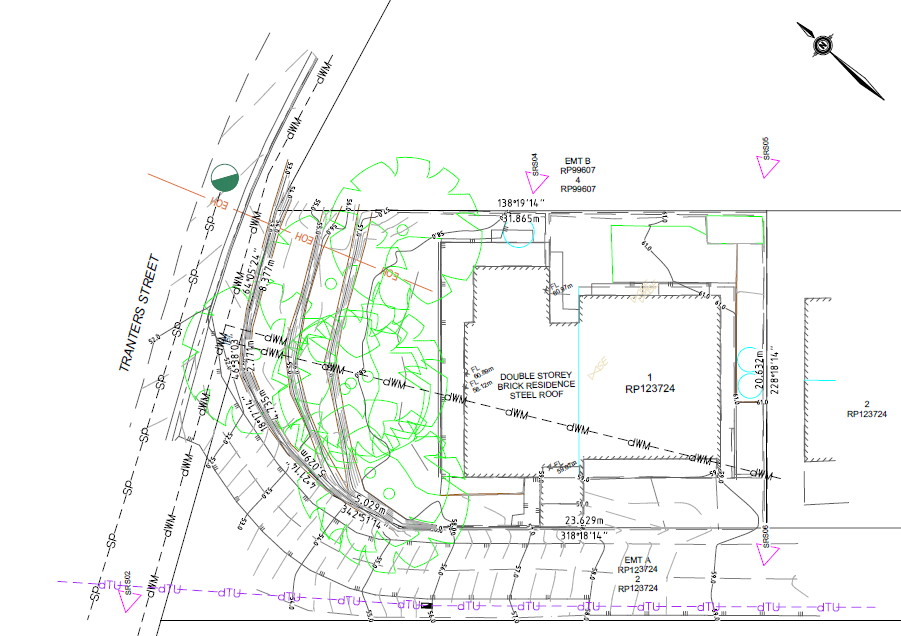
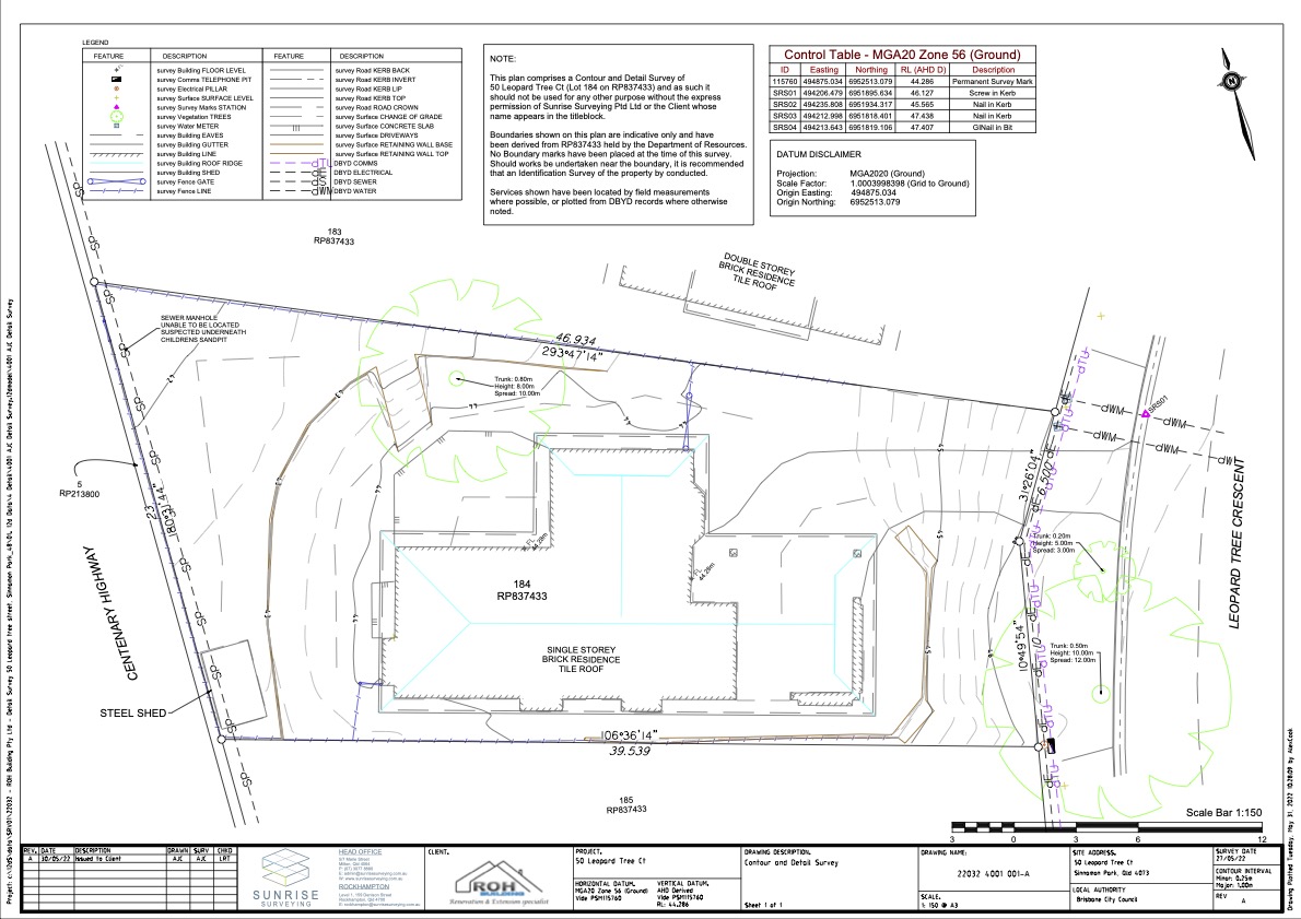
A detail survey is used to locate and map the major features of a piece of land for planning and construction purposes. This includes things such as man-made structures, vegetation, visible utilities and more. Detail surveys also identify the contours of the land and can be used to generate 3D terrain models.
Detail surveys are typically combined with other services – such as cadastral surveys and construction surveys. This gives you full insight into how a piece of land is being used, how it can be used, and any restrictions over the property.
When is a Detail Survey Required?
Detail surveys are a requirement when lodging planning applications with the local council. You will need a detail survey when:
- Constructing new buildings on a property
- Extending or carrying out major renovations to an existing building
- Planning major works, such as residential and commercial development
- Assessing drainage issues
- Plotting known flood levels
Beyond this, detail surveys are also used to accurately value a property, and they’re highly useful throughout the planning process. Having a property boundary survey that has information that is accurate and up to date about a property allows designers, architects and engineers to understand the parcel of land they’re working with.
Combined with other types of survey data – such as underground utility surveys – this can support the entire building process, from planning through to approvals, engineering, construction and verification.
What Information is Included in a Detail Survey?
A detail survey shows the major visible features of a property, including:
- Existing structures on the land
- Major trees and vegetation
- Terrain and contours
- Retaining walls
- Fences
- Spot levels
- Floor levels of existing structures
- Ridge and gutter heights
- Existing visible services (such as power poles)
- Outlines of structures on neighbouring properties
- Details about neighbouring structures
- Australian Height Datum (AHD) reference
This information will be compiled into a detail map showing the major features of a property. The corners and boundaries of the property will also be included in the map, however these will be drawn from existing title data. If boundaries have shifted, or if boundaries need to be marked for design or construction work, you will also need to conduct boundary surveys.
Detail surveys are limited to providing information about the subject property. However, a detail survey may include some information about neighbouring properties and structures, especially if these affect the design process. For example, the survey might show the positioning of windows on a neighbouring building so that an architect can account for privacy.
Accompanying Types of Survey
Development, design, renovation and construction projects require a wide range data, and detail surveys are just one piece of the puzzle. Most new projects are also supported by cadastral surveys, which provide information about the exact location of property corners and boundaries.
Depending on the survey information available from the titles office, most development projects also require an up to date cadastral survey. A cadastral survey gives you a full picture of the property by researching, mapping and marking:
- Property boundaries and corners
- Property size and layout
- Easements, restrictions and covenants over the land
This information plays a critical role in the design and approvals process. Once a project reaches the construction phase, surveyors will also provide construction and engineering surveys. These surveys are used to establish the site and mark out the location of new structures, ensuring works are carried out with a high degree of accuracy.
Make Effective Decisions with a Detail Survey from Sunrise Surveying!
Delivering any construction project is a major feat. The best way to ensure works are delivered on time and on budget is to invest in high quality surveys from the trusted team at Sunrise Surveying.
Sunrise Surveying offers a comprehensive range of surveying services throughout Brisbane, Toowoomba, Rockhampton and Yeppoon. We support residential and commercial construction projects with detail and cadastral surveys that can identify every feature of your property. When you need data to make more effective decisions, work with a land surveyor who can provide accurate, up to date information that allows you to achieve your project goals.
Contact us today to discuss your next project and we’ll put together a tailored survey package that supports your work.